gun violence data
2020-Jan-27, Monday 09:37 amColorado State Representative Tom Sullivan (who entered politics after his child was killed in the 2012 Aurora shooting) posted a tweet that caught my attention. There's a website called TheTrace.org that tracks gun violence information. They've got a very convenient interactive map where you can see data points for the whole USA. They currently have data for 2014-2019, both fatal and non-fatal injuries. It's eye-opening.
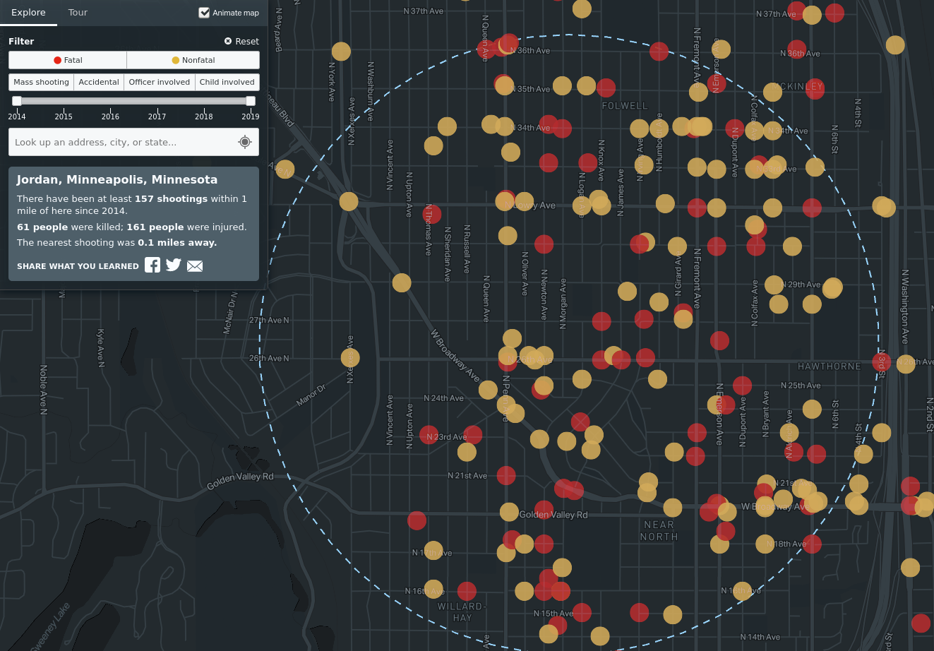
I plugged in my location and their map showed me this result. (As always, click photos for larger versions.)

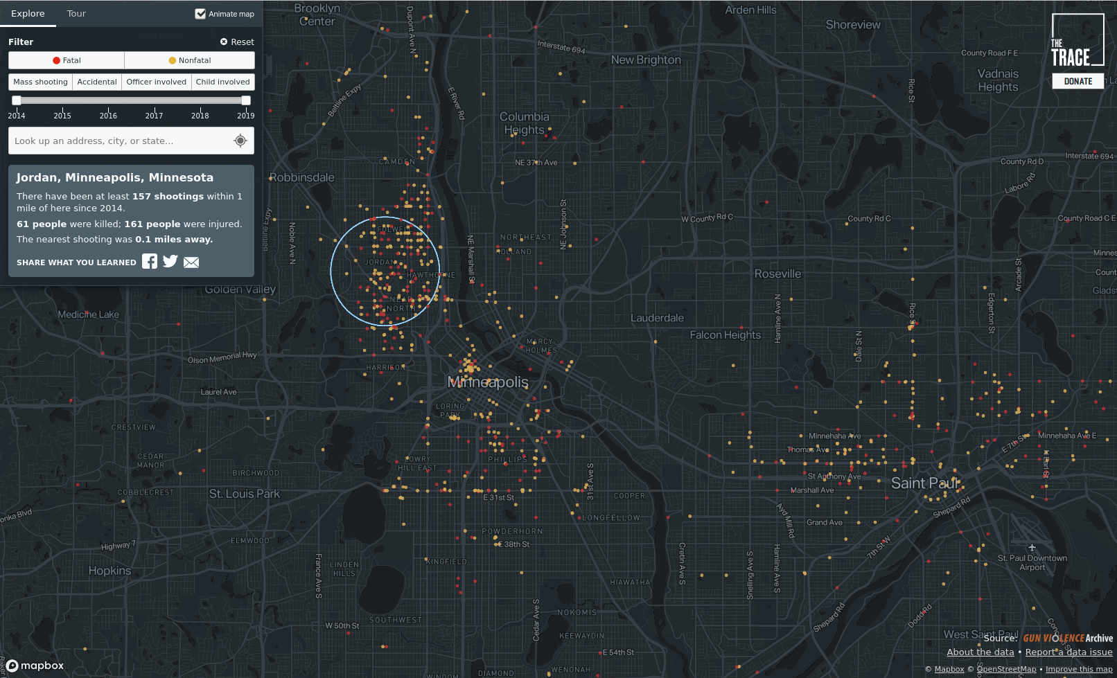
My neighborhood has seen 61 killed, 161 injured, all within 1 mile of my house since 2014. It's clearly concentrated just in this area, because the Twin Cities as a whole (and even St. Paul which has made local news recently for some killings) are not nearly as bad as my Jordan neighborhood, the area in that circle with my house at the epicenter.

Their interactive map doesn't work well on smartphones (low cpu and memory), but it works quite well on a full computer. I used their map to zoom all over the USA. I found only two areas that seemed as densely clustered as here: certain areas of Chicago and New York City.
I am quite disappointed in my Minneapolis City Council. Two of their members, in particular, campaigned on the issue of gun violence here in NOMI (NOrth MInneapolis). I don't know what they've done to help. My house has been better during the last year or two, in general, because the crack house next door was sold to someone even older than me. They are much less bothersome, and I'm not woken at night by people threatening to kill someone under my bedroom window.
Still, though, this area is bad. It's amongst the worst in the entire USA. And the convenient map at TheTrace.org can easily show it.
I plugged in my location and their map showed me this result. (As always, click photos for larger versions.)
My neighborhood has seen 61 killed, 161 injured, all within 1 mile of my house since 2014. It's clearly concentrated just in this area, because the Twin Cities as a whole (and even St. Paul which has made local news recently for some killings) are not nearly as bad as my Jordan neighborhood, the area in that circle with my house at the epicenter.
Their interactive map doesn't work well on smartphones (low cpu and memory), but it works quite well on a full computer. I used their map to zoom all over the USA. I found only two areas that seemed as densely clustered as here: certain areas of Chicago and New York City.
I am quite disappointed in my Minneapolis City Council. Two of their members, in particular, campaigned on the issue of gun violence here in NOMI (NOrth MInneapolis). I don't know what they've done to help. My house has been better during the last year or two, in general, because the crack house next door was sold to someone even older than me. They are much less bothersome, and I'm not woken at night by people threatening to kill someone under my bedroom window.
Still, though, this area is bad. It's amongst the worst in the entire USA. And the convenient map at TheTrace.org can easily show it.